


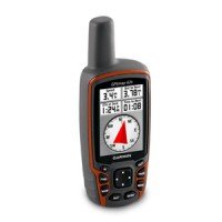
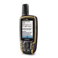
GPSMAP® 64st
Part Number: 010-01199-20
- Description
- Specs
Product Description
Rugged, Full-featured Handheld with GPS, GLONASS and Wireless Connectivity
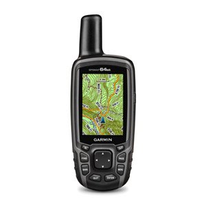
- 2.6″ sunlight-readable color screen
- High-sensitivity GPS and GLONASS receiver with quad helix antenna
- Preloaded TOPO U.S. 100K maps plus a 1-year BirdsEye Satellite Imagery subscription
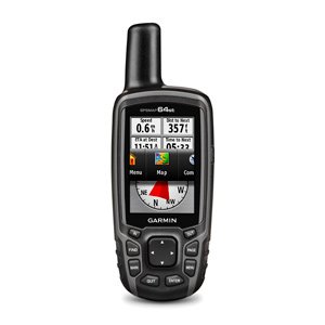
- 3-axis compass with barometric altimeter
- Wireless connectivity via Bluetooth® technology¹ or ANT+®

GPSMAP 64st features a 2.6” sunlight-readable color screen and a high-sensitivity GPS and GLONASS receiver with a quad helix antenna for superior reception. GPSMAP 64st includes a 3-axis electronic compass with barometric altimeter, wireless connectivity, and preloaded TOPO U.S. 100K maps plus a 1-year BirdsEye Satellite Imagery subscription.
Explore the Terrain
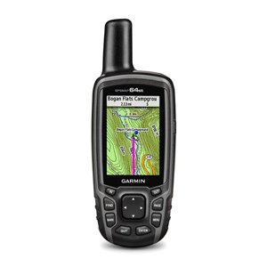
GPSMAP 64st comes with a worldwide basemap with shaded relief and is preloaded with TOPO 100K, which includes coverage of the full U.S., including Alaska, Hawaii and Puerto Rico. Plus it includes a 1-year BirdsEye Satellite Imagery subscription — all the tools for serious climbing or hiking. Map detail includes national, state and local parks and forests, along with terrain contours, elevation information, trails, rivers, lakes and points of interest.
Get Your Bearings
GPSMAP 64st has a built-in 3-axis tilt-compensated electronic compass, which shows your heading even when you’re standing still, without holding it level. Its barometric altimeter tracks changes in pressure to pinpoint your precise altitude, and you can even use it to plot barometric pressure over time, which can help you keep an eye on changing weather conditions.
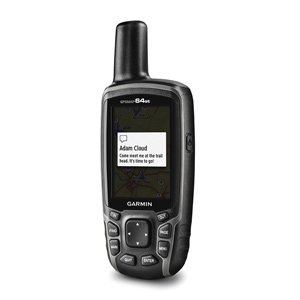
Share Wirelessly
Share your waypoints, tracks, routes and geocaches wirelessly with other compatible devices. Your friends can enjoy your favorite hike or cache without waiting for you to plug in to your computer — simply press “send” to transfer your information to another Garmin handheld.
GPSMAP 64st also connects to compatible Garmin devices, including VIRB™ and accessory sensors, including tempe™ and heart rate monitor.
Stay Connected
With Smart Notification you can wirelessly receive email, texts and alerts from your compatible iPhone® 4s or later. Stay connected without having to dig into your backpack for your smartphone.
Keep Your Fix
With its quad helix antenna and high-sensitivity, GPS and GLONASS, receiver, GPSMAP 64st locates your position quickly and precisely and maintains its location even in heavy cover and deep canyons. The advantage is clear — whether you’re in deep woods or just near tall buildings and trees, you can count on GPSMAP 64st to help you find your way when you need it the most.
Add Maps
GPSMAP 64st comes with a built-in worldwide basemap with shaded relief, preloaded TOPO 100K and a 1-year subscription of BirdsEye Satellite Imagery for a photo-realistic view. Adding more maps is easy with our array of detailed topographic, marine and road maps. With 8 GB of onboard memory and microSD™ card slot, you can conveniently download TOPO 24K maps and hit the trail, plug in BlueChart® g2 preloaded cards for a great day on the water or City Navigator NT® map data for turn-by-turn routing on roads (see maps tab for compatibility). In addition, the 64st is compatible with Garmin Custom Maps, a map format that allows you to transform paper and electronic maps easily into downloadable maps for your device, for free.
Find Fun
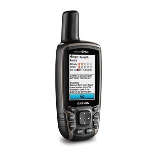
GPSMAP 64st supports paperless geocaching with 250,000 preloaded caches with hints and descriptions fromGeocaching.com, and has a 16-hour battery life. By going paperless, you’re not only helping the environment, but also improving efficiency. GPSMAP 64st stores and displays key information, including location, terrain, difficulty, hints and descriptions, which means there’s no more manually entering coordinates and paper printouts! Slim and lightweight, 64st is the perfect companion for all your outdoor pursuits.
Plan Your Next Trip
Take charge of your next adventure with BaseCamp™, software that lets you view and organize maps, waypoints, routes and tracks. This free trip-planning software even allows you to create Garmin Adventuresthat you can share with friends, family or fellow explorers. BaseCamp displays topographic map data in 2-D or 3-D on your computer screen, including contour lines and elevation profiles. It also can transfer an unlimited amount of satellite images to your device when paired with a BirdsEye Satellite Imagery subscription.
Physical & Performance |
|
| Physical dimensions | 2.4" x 6.3" x 1.4" (6.1 x 16.0 x 3.6 cm) |
| Display size, WxH | 1.43" x 2.15" (3.6 x 5.5 cm); 2.6" diag (6.6 cm) |
| Display resolution, WxH | 160 x 240 pixels |
| Display type | transflective, 65-K color TFT |
| Weight | 8.1 oz (230 g) with batteries |
| Battery | 2 AA batteries (not included); NiMH or Lithium recommended |
| Battery life | 16 hours |
| Water rating | IPX7 |
| High-sensitivity receiver | |
| Interface | high-speed USB and NMEA 0183 compatible |
| Barometric altimeter | |
| Electronic compass | Yes (tilt-compensated 3-axis) |
| Unit-to-unit transfer (shares data wirelessly with similar units) | |
Maps & Memory |
|
| Basemap | |
| Preloaded maps | yes (topographic) |
| Ability to add maps | |
| Built-in memory | 8GB |
| Accepts data cards | microSD™ card (not included) |
| Custom POIs (ability to add additional points of interest) | |
| Waypoints/favorites/locations | 5000 |
| Routes | 200 |
| Track log | 10,000 points, 200 saved tracks |
Outdoor Features |
|
| Automatic routing (turn by turn routing on roads) | Yes (with optional mapping for detailed roads) |
| Geocaching-friendly | Yes (Paperless) |
| Custom maps compatible | |
| Hunt/fish calendar | |
| Sun and moon information | |
| Tide tables | Yes (with optional Bluechart) |
| Area calculation | |
| Picture viewer | |
Garmin Connect™ |
|
| Garmin Connect™ compatible (online community where you analyze, categorize and share data) | |
Additional |
|
| Additional | Smart Notifications: yes
Live Tracking: yes (with Garmin Connect™ Mobile) |
Related Products
-
 Read MoreQuick View
eTrex® 30x
Part Number: 010-01508-10
-
 Read MoreQuick View
GPSMAP 62s GPS
GPS Hand Held Garmin 62S
-

 Read MoreQuick View
eTrex® 20x
-
 Read MoreQuick View
eTrex® 10
Part Number: 010-00970-00
-
 Read MoreQuick View
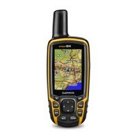
GPSMAP® 64
Part Number: 010-01199-00
-
 Read MoreQuick View
Garmin eTrex GPS
Garmin eTrex GPS receiver
